Capitol Reef National Park Overview
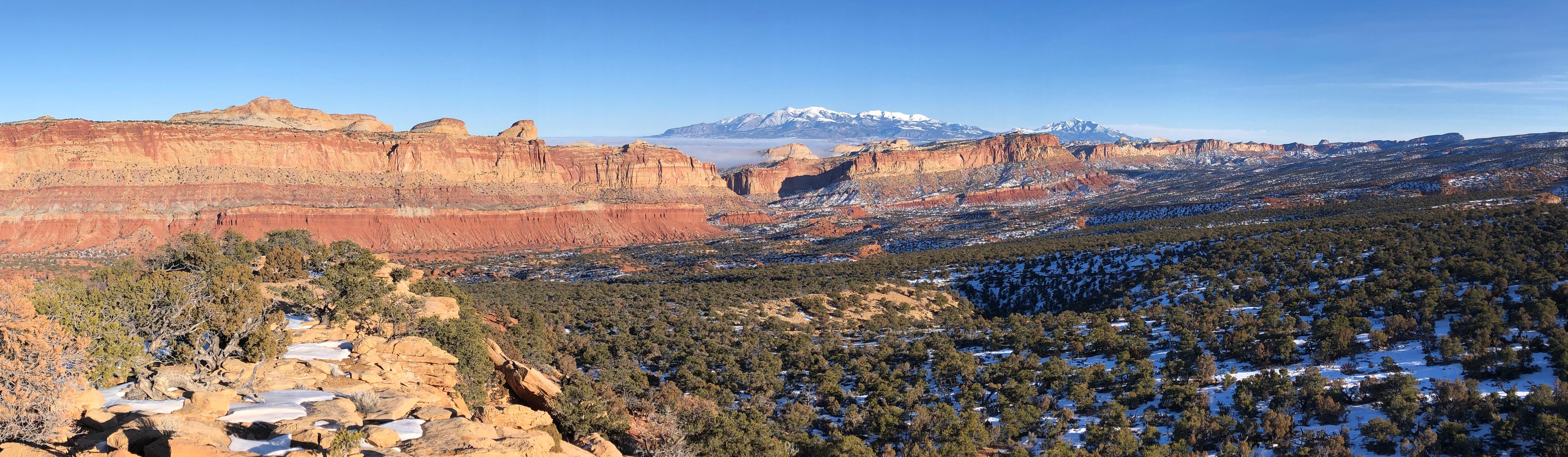
Capitol Reef National Park protects about 241,904 acres of cliffs, domes, canyons, bridges, orchards, desert washes, and the Waterpocket Fold, a long wrinkle in the earth where tilted rock layers define the landscape. The park recorded 1,388,476 recreation visits in 2025, making it one of Utah's quieter but increasingly popular canyon-country parks. The Fruita area, Scenic Drive, and nearby trailheads are the easiest starting points for most visitors.
Compared with some other Utah parks, Capitol Reef often feels quieter and more spread out. Visitors can focus on the paved Scenic Drive and Fruita area, head into day-hike canyons such as Grand Wash and Capitol Gorge, or plan more remote trips into Cathedral Valley, the Waterpocket District, and backcountry routes.
Capitol Reef was first protected as a national monument on August 2, 1937, and became a national park on December 18, 1971. The park preserves Fremont culture rock art, pioneer orchards and buildings, and a geologic story that stretches across nearly 100 miles of folded sandstone country.
For more information see the park's Wikipedia page.
For official park information, visit the official NPS page.
Top Hikes
Use the NPS Hiking page for current Capitol Reef trail conditions and heat guidance before hiking. Many routes are exposed, and water is not available at most trailheads.
Hickman Bridge Trail is a 1.8-mile (2.9 km) round-trip hike with about 400 feet (122 m) of elevation gain to a large natural bridge and canyon views near the Fremont River.
Grand Wash Trail is a 4.4-mile (7.1 km) round-trip canyon walk with about 200 feet (61 m) of elevation gain through a broad wash and narrow rock walls.
Cassidy Arch Trail is a 3.4-mile (5.5 km) round-trip hike with about 670 feet (204 m) of elevation gain to slickrock views above Grand Wash and the arch overlook.
Rim Overlook Trail is a 4.6-mile (7.4 km) round-trip hike with about 1,110 feet (338 m) of elevation gain to views over Fruita and the Waterpocket Fold.
Navajo Knobs is the longer Capitol Reef day hike, a 9.4-mile (15.1 km) round trip with about 1,620 feet (494 m) of elevation gain to a high viewpoint above the Fruita area.
Capitol Reef National Park Backpacking
Backpacking is available in remote sections of the park, including canyon routes and high-desert terrain beyond the main visitor corridor. Overnight trips require careful water planning, weather awareness, and backcountry permits where required, especially because flash floods and rough roads can change conditions quickly.
Things to Do in Capitol Reef National Park
Use the NPS Things To Do page for current activity ideas, seasonal guidance, accessibility notes, and park alerts before planning your visit.
The Fruita area and Scenic Drive are the easiest places to start a Capitol Reef visit. Visitors can see orchards, historic buildings, petroglyphs, canyon walls, and classic overlooks without committing to remote roads.
Scenic drives are a major part of the Capitol Reef experience because the landscape stretches far beyond the main Fruita corridor. Cathedral Valley, Notom-Bullfrog Road, and the Waterpocket District are memorable routes when road and weather conditions allow.
Canyoneering and remote desert travel are available for prepared visitors in more isolated parts of the park. Flash floods, heat, water availability, and rough roads should shape every plan.
Capitol Reef National Park Camping and Lodging
Fruita Campground is the only developed campground in Capitol Reef, with sites in the historic Fruita area near orchards, the visitor center corridor, and Scenic Drive access. Use the NPS Camping page for current reservation and group-site details.
Cathedral Valley Campground is a primitive campground in the park's remote northern district. It has limited services and depends on road and weather conditions, so high-clearance travel planning is important.
Cedar Mesa Campground is a primitive campground in the southern part of the park. Campers should expect fewer services, rougher access, and more self-reliant desert travel than at Fruita.
Backcountry camping is available by permit in remote areas, but visitors should plan around flash floods, heat, water availability, and route-finding.
Fruita Campground reservations are handled through Recreation.gov when sites are reservable.
Official Capitol Reef National Park Resources
Use the official NPS page, park map, and current alerts, plus reservation links when planning a trip to Capitol Reef National Park.