Great Basin National Park Overview
Great Basin National Park protects about 77,180 acres of ancient bristlecone pines, Lehman Caves, dark night skies, alpine lakes, sagebrush basins, limestone formations, and Wheeler Peak in eastern Nevada. The park recorded 161,210 recreation visits in 2025, making it a quieter high-desert and mountain alternative to many western parks. The park rises from sagebrush valleys into alpine terrain, giving visitors a mix of cave tours, scenic drives, stargazing, and high-elevation hiking.
Lehman Caves is a major draw and requires tour planning, while Wheeler Peak Scenic Drive opens access to cooler forests, alpine lakes, and trailheads when the road is snow-free. Great Basin feels remote compared with many western parks, and that distance is part of its appeal for night skies and quieter trails.
Lehman Caves was first protected as a national monument in 1922, and Great Basin National Park was established on October 27, 1986. The park preserves Basin and Range geology, Indigenous history, mining-era traces, high-elevation ecosystems, and some of the darkest skies in the National Park System.
For more information see the park's Wikipedia page.
For official park information, visit the official NPS page.
Top Hikes
Use the NPS Hiking information for current Great Basin trail conditions. Wheeler Peak area hikes are high elevation and can hold snow well into the season.
Alpine Lakes Loop is a 2.7-mile (4.3 km) loop with about 600 feet (183 m) of elevation gain past Stella Lake and Teresa Lake below Wheeler Peak.
Bristlecone Pine Trail is a 2.8-mile (4.5 km) round trip with about 600 feet (183 m) of elevation gain to ancient bristlecone pines.
Bristlecone and Glacier Trail is about 4.6 miles (7.4 km) round trip with about 1,100 feet (335 m) of elevation gain to bristlecones and the rock glacier below Wheeler Peak.
Lexington Arch Trail is about 5.4 miles (8.7 km) round trip with about 820 feet (250 m) of elevation gain to a large limestone arch in a quieter part of the park.
Wheeler Peak Trail is the long summit hike, about 8.6 miles (13.8 km) round trip with roughly 2,900 feet (884 m) of elevation gain to the park's highest peak.
Great Basin National Park Backpacking
Backcountry camping is available with low-impact practices and careful route planning. Longer trips can link alpine basins, ridges, and forested drainages, but visitors should prepare for altitude, storms, cold nights, and limited water away from reliable drainages.
Things to Do in Great Basin National Park
Use the NPS Things To Do page for current activity ideas, seasonal guidance, accessibility notes, and park alerts before planning your visit.
Lehman Caves tours are one of the main things to do in Great Basin National Park, and reservations should be checked before arrival. The cave system adds a very different experience from the park's high desert and mountain scenery.
Wheeler Peak Scenic Drive is a seasonal highlight when the road is open. It connects lower sagebrush country with cooler forests, high-elevation overlooks, picnic areas, and some of the park's best mountain views.
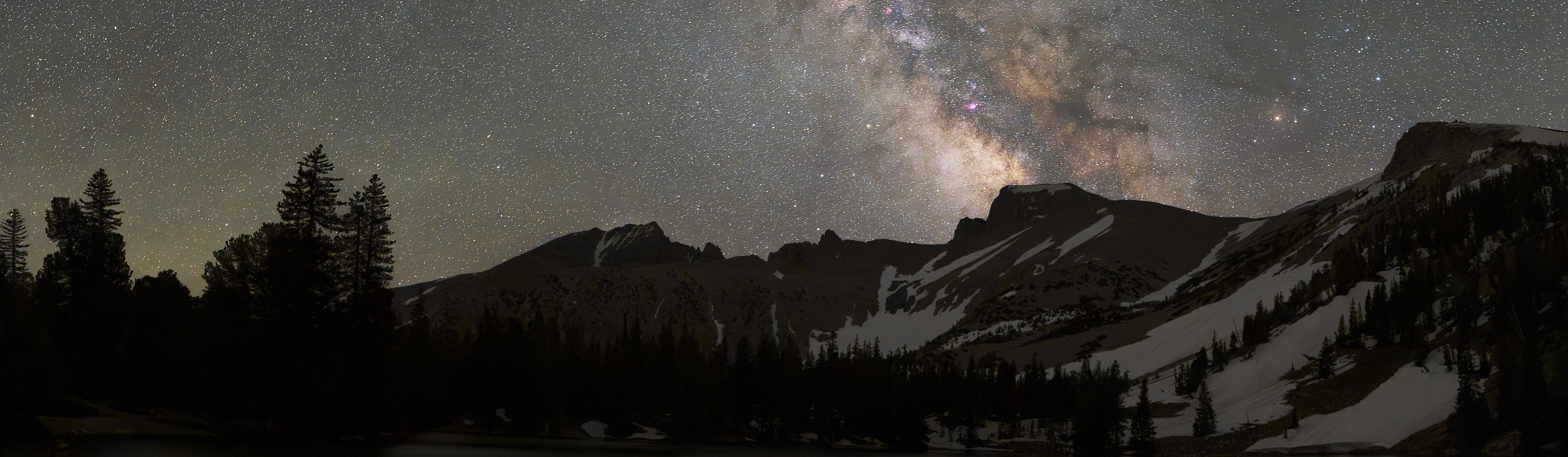
Stargazing is a major Great Basin activity because the park has famously dark night skies. Camping, astronomy programs, and quiet viewpoints make the park especially appealing for night-sky travel.
Great Basin National Park Camping and Lodging
Lower Lehman Creek Campground is one of Great Basin's lower-elevation developed campgrounds and can be useful earlier or later in the season than the highest campgrounds. Check the NPS Camping page for current opening dates and water status.
Upper Lehman Creek Campground sits higher along the Wheeler Peak Scenic Drive corridor and gives campers convenient access toward the park's mountain scenery when the road and campground are open.
Wheeler Peak Campground is the high-elevation campground closest to the Alpine Lakes, Bristlecone, Glacier, and Wheeler Peak trailheads. Snow, road closures, and short seasons can affect access.
Baker Creek Campground offers a quieter developed option along Baker Creek Road, with access to forested scenery and the west side of the park's trail network.
Grey Cliffs Campground includes group camping options and is useful for visitors who need more space than a standard individual campsite. Primitive camping and backcountry camping are also available with low-impact travel practices.
Reservable Great Basin campsites and group sites should be checked through Recreation.gov before arrival.
Official Great Basin National Park Resources
Use the official NPS page, park map, and current alerts, plus reservation links when planning a trip to Great Basin National Park.