Chiricahua National Park Overview
Chiricahua National Park in southeastern Arizona offers hikes through tall volcanic rock pinnacles, the scenic drive to Massai Point, Bonita Canyon camping, birdwatching, and dark night skies. This guide brings together maps, weather, current conditions, and official resources for planning a visit near Willcox.
Chiricahua became a national park on October 20, 2026, after more than a century as Chiricahua National Monument. The NPS designation announcement confirms the change. Some official pages, maps, and reservation listings still use the former monument name as they are updated.
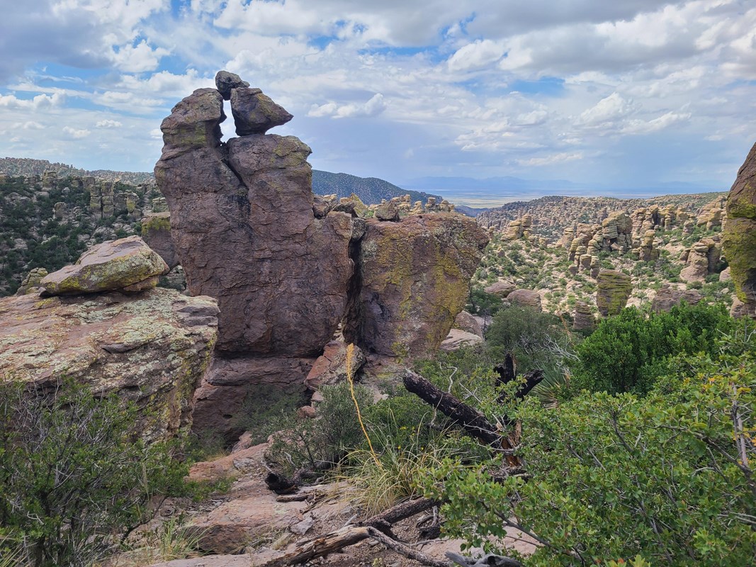
The park protects roughly 12,000 acres in the Chiricahua Mountains, where forest, grassland, and desert environments meet. Its rhyolite spires and balanced rocks developed from volcanic material dating back about 27 million years. The landscape is part of the homeland of the Chiricahua Apache.
For official park information, visit the official NPS page.
Top Hikes
Use the NPS Hiking page and Hiking guide and map to choose a route suited to your group. Trail lengths below follow the park's 2026 hiking guide; check conditions and trailhead access before setting out.
Massai Point Nature Trail is a 0.5-mile loop with views across the rock formations. The full loop includes uneven sections and steps; part of the route to the exhibit building is paved.
Echo Canyon Loop is a 3.3-mile circuit with about 560 feet of elevation change. It links Echo Canyon, Hailstone, and Ed Riggs trails through the park's rock formations.
Sugarloaf Peak is a 1.8-mile round trip with about 500 feet of elevation change to the historic fire lookout and broad mountain views.
Natural Bridge is a 4.7-mile round trip with more than 1,000 feet of elevation change. The route crosses burned terrain and leads to a distant view of the bridge.
Heart of the Rocks from the visitor center is a strenuous 7.4-mile round trip with about 1,600 feet of elevation change. Allow ample daylight and discuss route choices with park staff before starting.
Scenic Drive and Viewpoints
The paved Scenic Drive climbs through Bonita Canyon toward the upper trailheads and Massai Point. Stop at designated pullouts and allow time for short walks at the viewpoints.
Vehicles longer than 24 feet and trailers are prohibited on the upper scenic drive. Campground access has different limits, so being able to reach your campsite does not mean your vehicle can continue to Massai Point. Check Directions and current conditions before arrival.
Chiricahua National Park Camping and Lodging
Bonita Canyon Campground is the in-park camping option. Reservations are made through Bonita Canyon reservations on Recreation.gov. Campsite sizes vary, and some driveways will not fit a trailer and tow vehicle together.
The campground has drinking water and flush toilets, but no showers or standard RV hookups. Review the equipment and driveway details for the individual site before booking.
The campground entrance has a dip that limits long vehicles; NPS lists a 29-foot limit for each vehicle or trailer including racks. Check the current campground instructions and seasonal fire restrictions before travel. Nearby communities, including Willcox, offer additional lodging and supplies.
History and Faraway Ranch
Chiricahua was first protected as a national monument in 1924. Faraway Ranch preserves part of the area's later homesteading and guest-ranch history. The Erickson family settled here in the 1880s, and Lillian Erickson Riggs and Ed Riggs later developed the guest ranch. Visit the official Faraway Ranch page for its history and access information.
Night Skies and Wildlife
Chiricahua is an International Dark Sky Park. The Night skies page describes stargazing locations including Massai Point and Echo Canyon Trailhead. Bring a light for walking, watch for wildlife on the road, and check the park calendar for ranger programs.
Birdwatching and wildlife viewing complement the hikes and scenic overlooks. Observe animals from a distance and store food securely at campsites.
Weather and Trip Planning
Summer thunderstorms can bring lightning and flash flooding; winter weather can leave snow or ice on roads and trails. Higher trails may be windy and exposed. Carry drinking water, sun protection, and layers, and check Current conditions before heading out.
Download directions and maps before leaving reliable cell coverage. NPS recommends paved approaches via Highway 186 from Willcox or Highway 181 from the southwest. Do not assume a suggested shortcut is suitable for your vehicle.
Fees and Visitor Center
As checked on October 21, 2026, the NPS Fees and passes page lists no entrance or parking fee. Campground charges are separate; confirm current information before your trip.
The visitor center normally opens from 8:30 a.m. to 4:30 p.m. Mountain Standard Time, with holiday or operational exceptions. Arizona does not observe daylight saving time here. Check Operating hours for the latest schedule.
Visiting with Pets
Pets are allowed on a leash no longer than six feet in the campground, paved parking areas, and designated lower trails around Bonita Creek, Silver Spur Meadow, and Faraway Ranch. They are not allowed on the trails through the upper rock formations or in park buildings. Check the official Pets page before choosing a hike; do not leave pets unattended.
Official Chiricahua National Park Resources
Use the official NPS park site, current conditions, hiking guide, campground information, and reservation links below when planning a visit to Chiricahua National Park.